


Curry County Precinct 3, Curry County, New Mexico
About
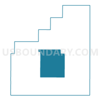
Outline

Summary
| Unique Area Identifier | 623377 |
| Name | Curry County Precinct 3 |
| County | Curry County |
| State | New Mexico |
| Area (square miles) | 161.76 |
| Land Area (square miles) | 161.39 |
| Water Area (square miles) | 0.36 |
| % of Land Area | 99.77 |
| % of Water Area | 0.23 |
| Latitude of the Internal Point | 34.53828310 |
| Longtitude of the Internal Point | -103.39183670 |
Maps


Graphs
Select a template below for downloading or customizing gragh for Curry County Precinct 3, Curry County, New Mexico


Neighbors
Neighoring Voting District (by Name) Neighboring Voting District on the Map
- Curry County Precinct 10, Curry County, NM
- Curry County Precinct 16, Curry County, NM
- Curry County Precinct 31, Curry County, NM
- Curry County Precinct 36, Curry County, NM
- Curry County Precinct 4, Curry County, NM
Top 10 Neighboring County Subdivision (by Population) Neighboring County Subdivision on the Map
Top 10 Neighboring Unified School District (by Population) Neighboring Unified School District on the Map
- Clovis Municipal Schools, NM (45,095)
- Melrose Public Schools, NM (1,156)
- Grady Municipal Schools, NM (340)
Top 10 Neighboring State Legislative District Lower Chamber (by Population) Neighboring State Legislative District Lower Chamber on the Map
- State House District 64, NM (28,070)
- State House District 67, NM (25,041)
- State House District 63, NM (24,938)